
Latest update
License Price
OS
Jacobs Flood Modeller (formerly known as ISIS) is an industry-standard 1D/2D hydrodynamic modeling suite for flood simulation. It enables users to build detailed models of river channels, floodplains, urban areas, and drainage networks to predict water levels, flow velocities, and flood extents under various rainfall and flow scenarios. The software is used globally for flood mapping (e.g., for regulatory Flood Risk Assessments), designing flood defenses, evaluating climate change impacts, and real-time flood forecasting.
Jacobs Flood Modeller 7.2.9 is a professional hydraulic modeling software designed for Hydrologists, Flood Risk Engineers, Water Resources Planners, Environmental Consultants, Government Agencies, and Academics involved in simulating river flows, surface water flooding, and urban drainage to assess flood risk, design mitigation schemes, and support planning and emergency response.
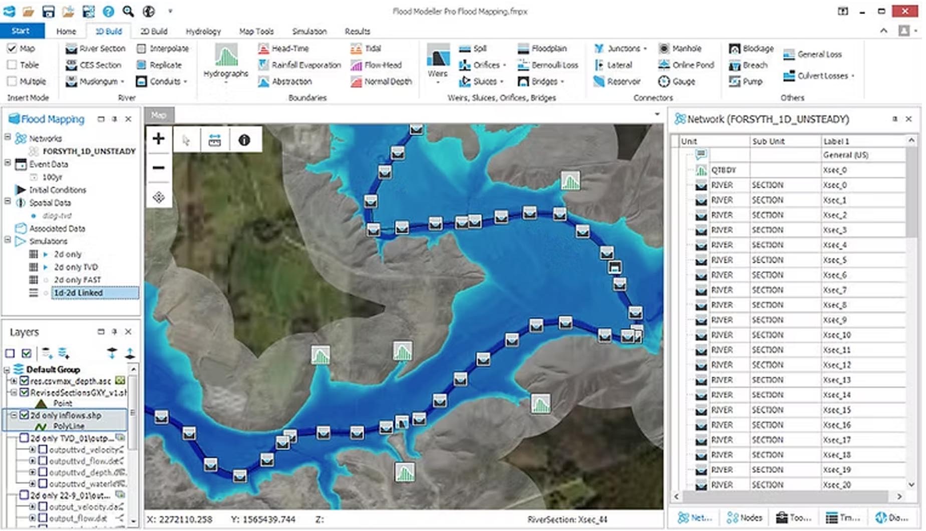
Integrated 1D-2D Hydraulic Modeling: Combines 1D river and pipe network modeling with 2D overland flow modeling for a comprehensive simulation of complex flood pathways.
Urban Flooding & Drainage Analysis: Specialized tools for modeling surface water flooding in built-up areas, integrating with sewer network models (SUDS, drainage systems).
Flood Risk Mapping & Visualization: Generates detailed flood inundation maps, hazard maps (depth/velocity), and animations to communicate risk to stakeholders and the public.
Real-Time Forecasting & Control: Capabilities to set up models for real-time flood forecasting and operational management of hydraulic structures (gates, weirs).
Climate Change & Scenario Analysis: Tools to assess the impact of future climate scenarios, land-use change, and different flood defense options on flood risk.
Data Integration & GIS Compatibility: Strong import/export functionality for terrain data (LiDAR, DEM), GIS layers, and linkage with hydrological models.
This update focuses on performance enhancements, improved solvers, and extended functionality for integrated water management.
Enhanced 2D Solver Performance: Optimizations to the TUFLOW 2D solver engine (often integrated or associated) for faster simulation times and better stability, especially for large-domain models.
Improved Urban Modeling Tools: New and refined features for detailed modeling of green infrastructure, permeable surfaces, and complex urban drainage interactions.
Updated User Interface & Workflow Management: Streamlined project setup and management tools within the Flood Modeller interface.
Expanded Data Format Support: Support for newer versions of standard geospatial data formats and improved interoperability with other modeling platforms.
Bug Fixes & Stability Improvements: General software robustness improvements based on user feedback.
OS: 64-bit Windows 10 or 11.
CPU: Multi-core Intel i5/i7 or equivalent (higher performance reduces simulation runtime).
RAM: 8 GB minimum (16 GB+ strongly recommended, 32 GB+ for large 2D models).
Storage: Fast SSD with substantial free space for terrain data and model results.
Graphics: Dedicated graphics card recommended for visualizing large result datasets.
Price: 285 $
Price Currency: $
Operating System: Windows
Application Category: Environmental Engineering
Latest update
License Price
OS


Reviews
There are no reviews yet.