klauPPK is a specialized geodetic processing software developed by Klau Geomatics, an industry leader in PPK hardware and geospatial data processing solutions. The software is specifically engineered for processing and analyzing geographic data collected during aerial mapping missions. It is typically used in conjunction with aerial camera payloads and drone systems, enabling users to precisely process GNSS observation data to achieve centimeter-level accuracy for photogrammetry projects, orthomosaic generation, and 3D mapping without the need for ground control points.
klauPPK is developed for aerial surveyors, photogrammetry specialists, drone/UAV operators, and geospatial mapping professionals. It is specifically designed for experts who integrate GNSS PPK (Post-Processed Kinematic) hardware with aerial cameras for high-precision geospatial data collection and processing.
Aerial Mapping-Optimized PPK Processing: Specialized workflows for processing GNSS data from UAV/drone flights, supporting tight integration with popular aerial camera systems and flight controllers.
Direct Camera Event Synchronization: Precise time synchronization between GNSS observations and camera trigger events, critical for achieving high positional accuracy of each captured image.
Seamless Integration with Photogrammetry Software: Export processed camera positions in formats directly compatible with leading photogrammetry suites (such as Pix4D, Agisoft Metashape, and Bentley ContextCapture) to streamline the aerial triangulation process.
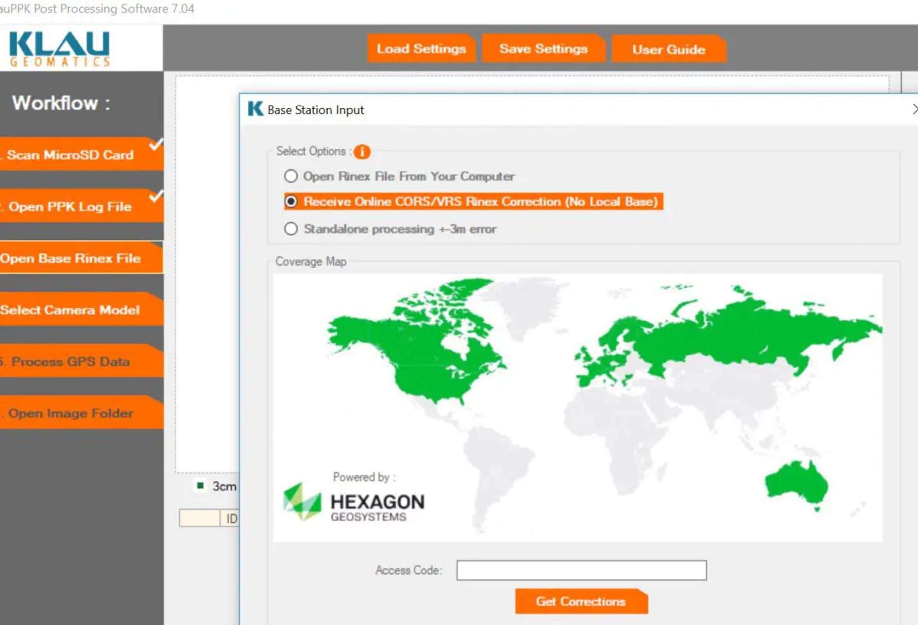
Base Station & CORS Network Flexibility: Process rover data against data from a local base station or leverage online CORS (Continuously Operating Reference Station) networks for correction.
Trajectory Smoothing & Analysis: Analyze and smooth the flight trajectory, visualize the flight path in 3D, and assess GNSS data quality throughout the mission.
Comprehensive Accuracy Reporting: Generate detailed reports on processing accuracy, including positional RMSE, number of fixed epochs, and baseline statistics to validate data quality for mapping deliverables.
Multi-GNSS Constellation Support: Utilizes data from all major GNSS constellations (GPS, GLONASS, Galileo, BeiDou) for robust positioning, especially in challenging environments.
This update focuses on enhanced workflow automation, expanded hardware support, and improved data quality tools:
Enhanced Flight Log Integration: Improved parsing and utilization of metadata from major drone flight controllers (e.g., DJI, senseFly) for more automatic and accurate project setup.
Support for New PPK Hardware: Added native support for the latest generation of Klau and third-party PPK modules and GNSS receivers used in aerial surveying.
Advanced Outlier Detection: New algorithms to automatically detect and flag periods of poor GNSS signal or potential multipath interference during flight, improving final output reliability.
Streamlined Project Template System: New feature to save and reuse processing configurations for specific camera/aircraft setups, saving time on repetitive projects.
Refined User Interface & Visualization: Updates to the trajectory visualization window and reporting module for clearer data interpretation and presentation of results to clients.
OS: Windows 10/11 (64-bit) version 21H2 or later
CPU: Multi-core processor, 2.0 GHz or higher
RAM: 8 GB minimum (16 GB recommended for processing long-duration flights or multiple missions)
Disk Space: 2 GB free space for installation
Other: Stable internet connection for accessing CORS networks and software updates. USB ports for connecting GNSS receivers.
Price: 185 $
Price Currency: $
Operating System: Windows
Application Category: Geospatial


Reviews
There are no reviews yet.