
Latest update
License Price
OS
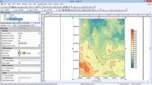
Golden Software Surfer is the industry-standard solution for 2D and 3D mapping, surface modeling, and spatial data visualization—trusted by scientists, engineers, and researchers worldwide for over three decades. Surfer transforms complex XYZ data into stunning, publication-ready maps and models through powerful gridding algorithms, advanced interpolation methods, and comprehensive visualization tools. Version 30.3.273 continues Golden Software’s legacy of innovation with enhanced performance, expanded file format support, and improved automation capabilities. Whether creating contour maps of groundwater contamination, modeling ore body volumes for mining operations, or visualizing bathymetric data for marine studies, Surfer delivers the precision, flexibility, and presentation quality that professional geospatial work demands.
This professional spatial data analysis and mapping software is designed for:
Geologists & Geophysicists creating detailed surface maps and analyzing subsurface data.
Environmental Scientists & Hydrologists modeling water quality, contamination plumes, and terrain features.
Mining Engineers & Exploration Geologists visualizing mineral deposits and planning extraction operations.
Civil Engineers & Land Surveyors performing site analysis, terrain modeling, and volume calculations.
Oceanographers & Marine Scientists mapping bathymetric data and studying coastal processes.
Comprehensive Algorithm Library:
Kriging: Geostatistical interpolation with variogram modeling
Inverse Distance Weighting (IDW): Fast, intuitive interpolation
Minimum Curvature: Smooth surface generation
Natural Neighbor: Local interpolation preserving data integrity
Triangulation with Linear Interpolation: Fast, exact interpolation
Radial Basis Functions: Flexible interpolation with multiple basis functions
Moving Average: Smoothing and generalization
Nearest Neighbor: Exact interpolation for categorical data
Local Polynomial: Trend surface analysis
Advanced Gridding Options:
Cross-validation for algorithm selection
Anisotropy modeling for directional data
Breakline and fault support
Gridding with barriers and boundaries
Point cloud to grid conversion
Map Types:
Contour Maps: Classic contour lines with customizable intervals
Base Maps: Import and display existing map data
Shaded Relief Maps: Illuminated terrain visualization
Image Maps: Raster overlay and display
Post Maps: Data point location display
Classed Post Maps: Categorized point symbols
Vector Maps: Flow direction and magnitude
Watershed Maps: Drainage basin analysis
3D Wireframe Maps: Surface representation
Map Customization:
Layered map composition
Color scheme control
Contour labeling options
Scale bars and north arrows
Graticules and coordinate grids
Transparency and blending
3D Visualization:
Rotatable, scalable 3D surface views
Multiple viewing perspectives
Surface draping over base maps
3D wireframe and solid surfaces
Fly-through animations
Export to 3D formats
Surface Analysis:
Slope and aspect calculation
Curvature analysis
Cut and fill volume calculations
Surface area and planar area
Profile extraction
Viewshed analysis
Statistical Tools:
Descriptive statistics
Histogram generation
Variogram modeling
Trend surface analysis
Residual calculation
Data filtering and transformation
Grid Math:
Combine multiple grids
Grid calculus operations
Filter and smooth grids
Resample and transform
Grid mosaic and merge
Import Formats:
GIS formats: SHP, DXF, KML, KMZ, GeoTIFF, MrSID
Grid formats: DEM, ASCII Grid, Surfer Grid, ESRI Grid
Spreadsheet: Excel (XLS, XLSX)
Text: CSV, TXT, DAT
Database: ODBC connections
Image: JPG, PNG, BMP, TIFF, GIF
Export Formats:
Image: PNG, JPG, TIFF, BMP, GIF
Vector: PDF, SVG, EPS, EMF
GIS: SHP, KML, GeoTIFF
Grid: Multiple grid formats
3D: VRML, X3D, 3D PDF
Coordinate Systems:
Extensive library of projections
Custom coordinate system definition
On-the-fly reprojection
Georeferencing of imported maps
Support for datum transformations
Geospatial Accuracy:
Precise coordinate handling
Geographic and projected coordinates
Multi-zone support
UTM, State Plane, and international systems
Generate profiles from surface grids
Multiple profile display
Cross-section extraction
Subsurface visualization
Distance-elevation plots
Export profile data
Slope maps and analysis
Aspect (direction of slope) mapping
Curvature calculation
Hillshade generation
Watershed delineation
Drainage network extraction
Visibility analysis
Golden Software Scripter:
Built-in scripting environment
Automate repetitive tasks
Batch processing
Custom tool development
Python Integration:
Python scripting support
Access Surfer functionality from Python
Integration with scientific Python ecosystem
Automate complex workflows
Cloud integration for project sharing
Seamless team collaboration
Version tracking
Shared data access
Remote project review
Enhanced Kriging Algorithms – Improved variogram modeling with faster computation
New Gridding Methods – Additional interpolation options for specialized applications
3D Visualization Improvements – Better rendering quality with faster performance
Expanded File Format Support – Latest GIS and image format compatibility
Python Integration Enhancements – Deeper scripting capabilities
Cloud Collaboration Features – Improved project sharing and team workflows
UI/UX Refinements – Streamlined interface with customizable workspace
Performance Optimizations – Faster grid generation and map rendering
Stability Improvements – Bug fixes and reliability enhancements
OS: Windows 7, 8, 10, or 11 (64-bit versions recommended)
Processor: Dual-core processor
RAM: 4 GB
Graphics: DirectX 10-compatible graphics card with 512 MB memory
Storage: 500 MB for installation (additional space for data files)
Display: 1280 × 720 screen resolution or higher
OS: Windows 10 or 11 (64-bit)
Processor: Quad-core processor or higher
RAM: 16 GB or more
Graphics: DirectX 12-compatible graphics card with 1 GB memory or more
Storage: 1 GB or more (depending on dataset size)
Display: Full HD (1920 × 1080) or higher resolution
Additional: Fast SSD for large datasets
Price: 125 $
Price Currency: $
Operating System: Windows
Application Category: Geospatial
Latest update
License Price
OS


Reviews
There are no reviews yet.