Visual OTTHYMO is a comprehensive hydrological modeling software based on the widely-used OTTHYMO methodology, originally developed in Canada. Version 6.2 provides an integrated Windows-based environment for simulating rainfall-runoff processes, routing flows through drainage networks, and analyzing stormwater management measures. It combines the robust OTTHYMO engine with modern graphical interfaces for efficient urban hydrological analysis and design.
Visual OTTHYMO is developed for hydrological engineers, urban drainage planners, municipal engineers, water resource consultants, and environmental regulators. It is specifically designed for professionals who need to model urban stormwater systems, analyze runoff, and design drainage infrastructure for flood control and water quality management.
Integrated Hydrological Modeling: Complete implementation of the OTTHYMO methodology for simulating urban and rural watershed hydrology, including rainfall-runoff processes, infiltration, and evapotranspiration.
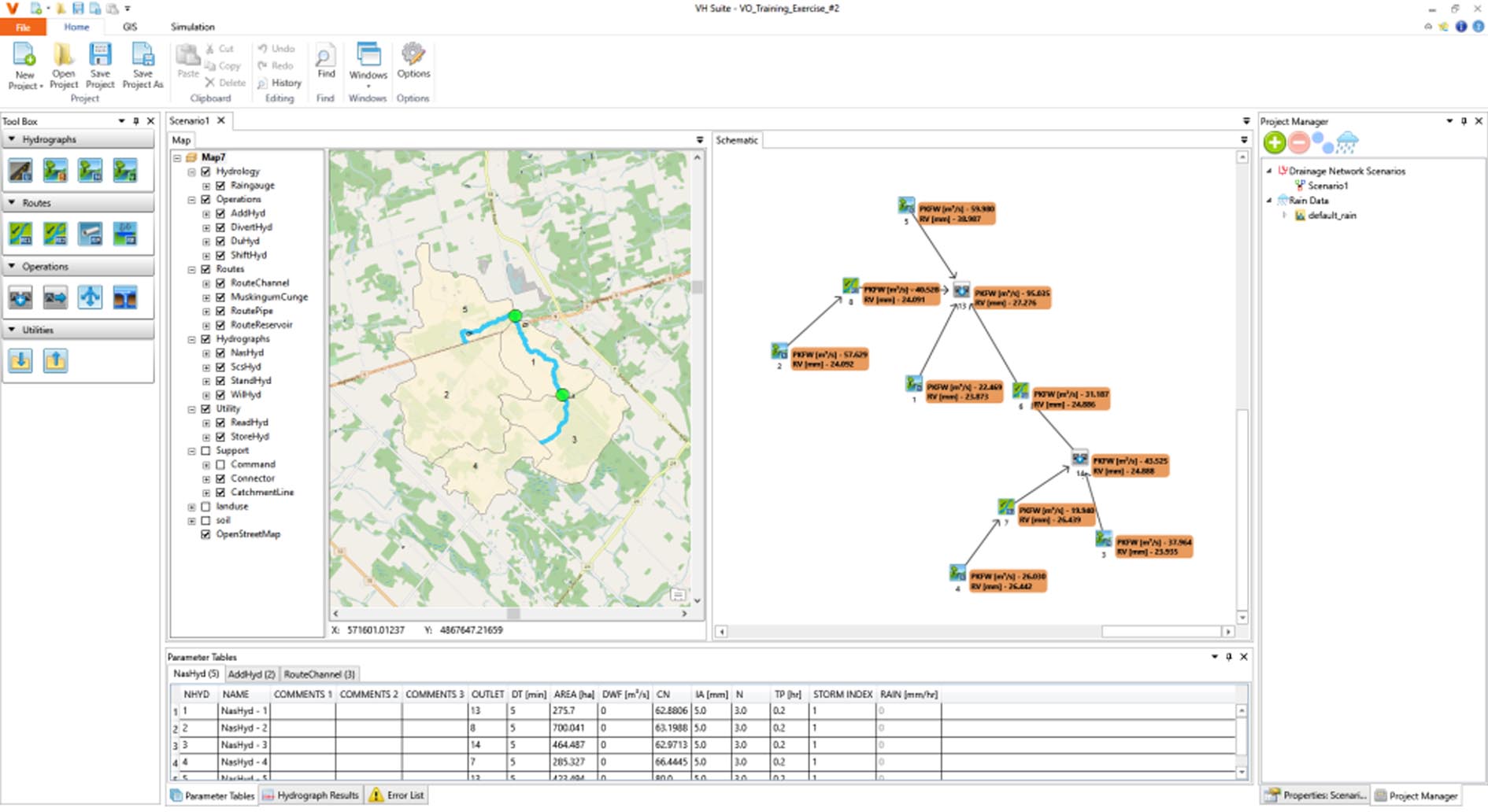
Urban Drainage System Analysis: Model complex drainage networks including storm sewers, channels, ponds, and control structures with dynamic routing capabilities.
Graphical Watershed Delineation: Visual tools for defining subcatchments, flow paths, and drainage networks using digital terrain data and aerial imagery.
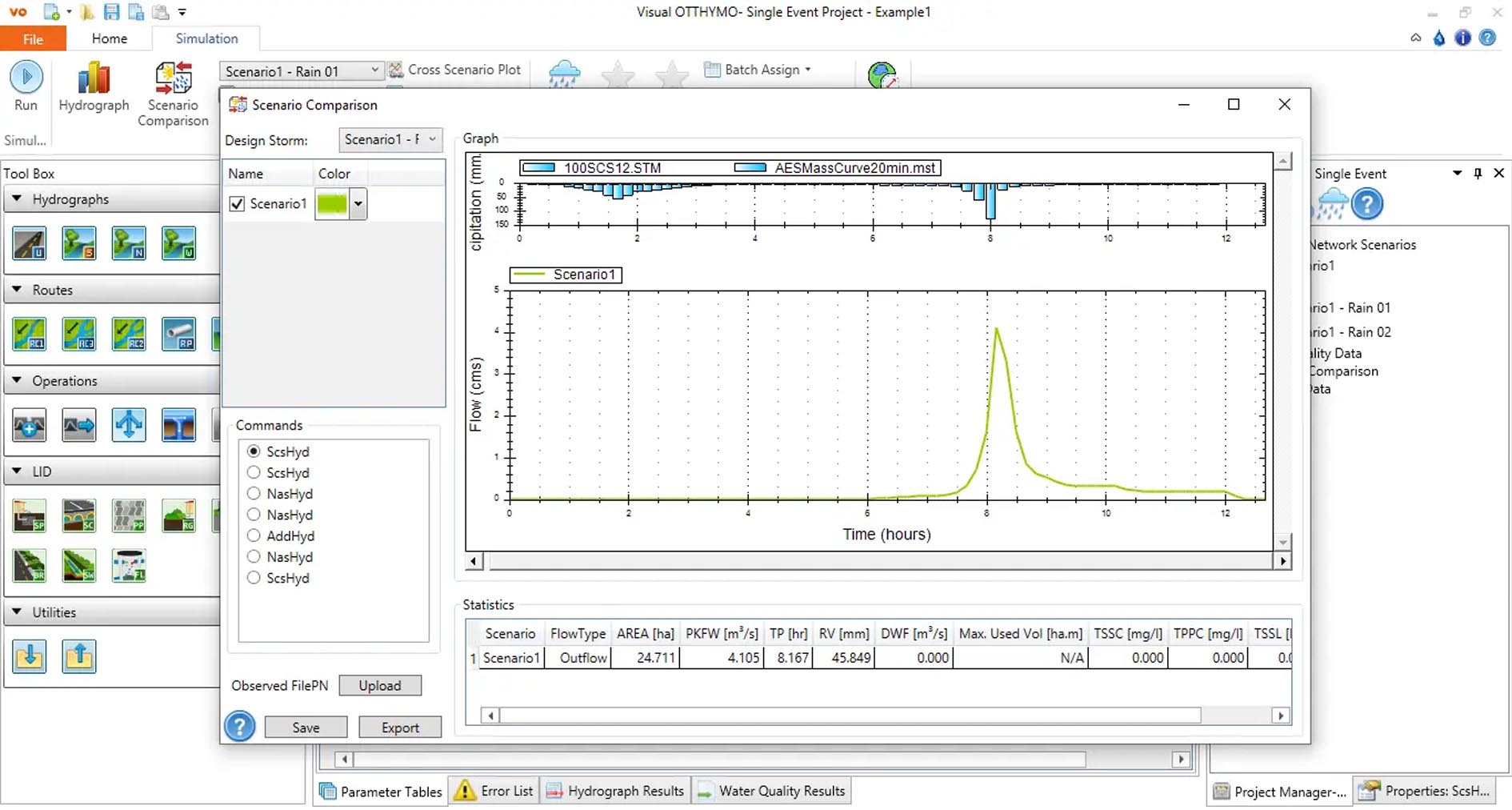
Climate & Rainfall Data Integration: Support for various rainfall data formats including synthetic design storms, historical rainfall series, and climate change scenarios.
Water Quality Modeling: Capabilities for simulating pollutant buildup and washoff processes, supporting Best Management Practice (BMP) evaluation for water quality control.
Scenario Management & Comparison: Tools for creating and comparing multiple design scenarios to evaluate different stormwater management strategies and infrastructure options.
Comprehensive Reporting & Visualization: Generate detailed hydrological reports, hydrographs, and system performance metrics with graphical output for analysis and presentation.
This version introduces important updates focusing on user interface improvements, data handling, and analysis capabilities:
Enhanced Graphical User Interface: Modernized interface with improved navigation, ribbon-style menus, and context-sensitive tools for more efficient workflow.
Expanded Data Import Capabilities: Improved support for importing GIS data formats, CAD drawings, and digital elevation models for more accurate watershed representation.
Updated Climate Data Libraries: Inclusion of more recent Intensity-Duration-Frequency (IDF) curves and climate datasets for various regions.
Performance Optimizations: Faster calculation engine for processing large watersheds and complex drainage networks, reducing simulation time.
Improved Reporting Templates: Enhanced report generation with customizable templates and better integration with Microsoft Office applications.
OS: Windows 7 SP1, 8.1, 10, or 11 (64-bit recommended)
CPU: 1 GHz processor or faster (2.0+ GHz recommended for large models)
RAM: 4 GB minimum (8 GB recommended for complex watershed modeling)
Disk Space: 2 GB free space for installation
Other: Microsoft .NET Framework 4.6 or later; Administrative rights required for installation.
Price: 185 $
Price Currency: $
Operating System: Windows
Application Category: Environmental Engineering


Reviews
There are no reviews yet.